Copper Canyon is not a single canyon. It is six major canyons and about twenty smaller ones carved into the Sierra Madre Occidental of Chihuahua state, collectively four times larger than the Grand Canyon and in places deeper. But the comparison to Arizona misses the point. The Grand Canyon is a drive-up national park with guardrails and gift shops. Copper Canyon is a lived-in landscape where Tarahumara (Raramuri) families still farm the canyon bottoms, a train line threads through tunnels blasted into the cliff walls, and the nearest paved road might be three hours away.
In This Article
I rode the Chepe train both directions — Los Mochis to Creel and back — and spent a week based in Creel exploring the canyon rim, a village at the bottom, and the long dirt road to Batopilas. It is the part of Mexico that feels least like Mexico and most like somewhere you need to earn.
The Chepe Train
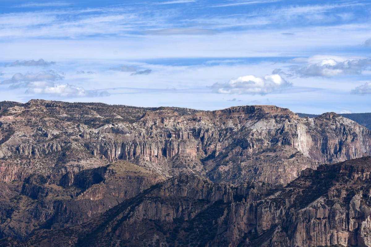
The Chepe (Chihuahua al Pacifico railway) runs 653 kilometres from Los Mochis on the Pacific coast to the city of Chihuahua, climbing from sea level to over 2,400 meters through 86 tunnels and across 37 bridges. The scenery between El Fuerte and Creel is some of the most dramatic railway landscape in the Americas — the train clings to canyon walls, crosses deep gorges, passes through subtropical forest into pine highlands.
Two versions of the train run the route. The Chepe Express is the tourist service: panoramic windows, dining car, bar, assigned seats. It runs Los Mochis to Creel with stops at El Fuerte, Bahuichivo and Divisadero. The Chepe Regional is the local service: the full route to Chihuahua with more stops, cheaper tickets, and a more authentic atmosphere. The Regional gets you to smaller stations that the Express skips.
Start from Los Mochis heading east. The morning sun lights the east-facing canyon walls and you get the dramatic scenery building as the train climbs rather than descending into flatland. The Express departs Los Mochis early morning. Book the left side of the train for the best canyon views on the eastbound journey.
Tickets for the Express run about 3,000-5,000 pesos depending on class and route segment. The Regional is roughly half that. Book at chepe.com.mx or at station ticket offices. In high season (October-March), the Express sells out — book at least a few days ahead.
El Fuerte
Most travellers starting from Los Mochis skip straight to the canyon, but El Fuerte is worth an overnight stop. A small colonial town on the Rio El Fuerte, founded in 1564, it has a pleasant plaza, a restored fort-turned-museum (Fuerte de Montesclaros), and riverside walks. Hotels are cheap and the town is quiet after dark. The morning train departure from El Fuerte puts you in the canyon by midday with good light.
Divisadero
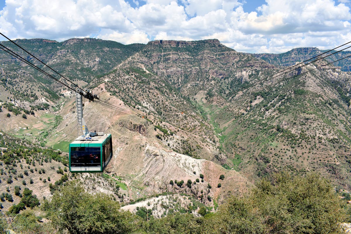
The Chepe stops at Divisadero for 15 minutes so passengers can look over the canyon rim. The view here is the classic Copper Canyon photograph — three canyons converging below you, the opposite rim several kilometres away, the floor hundreds of metres down. Tarahumara women sell baskets and woven goods at the viewpoint.
The adventure park at Divisadero has a cable car (teleferico) spanning 2.75 kilometres across the canyon — the longest in Mexico. There is also a zip line over the gorge and a via ferrata route along the cliff face. The cable car ride alone is worth stopping for if you have time between trains.
Creel
Creel is the main base for exploring the canyons. A small logging and tourism town at 2,300 metres in the pine forest, it has hostels, hotels, tour operators and a Tarahumara craft market on the plaza. The climate is cold in winter — frost and occasional snow from November through February. Summer days are pleasant but afternoon rain is common.
From Creel you can reach canyon viewpoints, Tarahumara communities, hot springs, the Cascada de Cusarare (a 30-metre waterfall about 25km from town), and the bizarre rock formations at the Valley of the Mushrooms and Valley of the Frogs. Most of these are accessible by organised day trips or by renting a car or ATV from Creel.
Accommodation ranges from 300-peso dorm beds to 2,000-peso hotel rooms. The Best Western in Creel is surprisingly decent. There are a few lodges on the canyon rim outside town — pricier but the views justify it. Restaurants in town are simple — hearty northern Mexican food, beans, meat, tortillas.
Batopilas
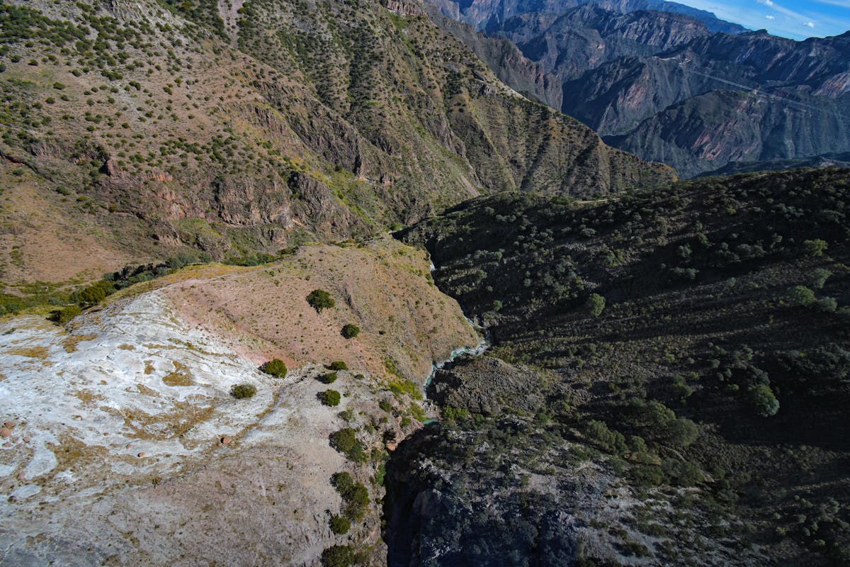
Batopilas is the canyon-bottom experience. A tiny former silver mining town at 500 metres elevation, reached by a 5-6 hour drive from Creel on a dirt road that drops 1,800 metres down the canyon wall. The road is one lane, no guardrails, cut into the cliff face. It is spectacular and terrifying in equal measure.
At the bottom the climate flips — tropical heat, mangoes and bougainvillea while Creel above is cold pine forest. Batopilas has a few basic hotels, a river you can swim in, and the Lost Cathedral (Satevo Mission) — a ruined 17th-century church about 7km downstream that nobody knows who built or why it is there.
A bus runs from Creel to Batopilas a few times per week. Check schedules locally — they change. The ride itself is an experience. Some travellers hire a driver from Creel for the round trip.
Tarahumara (Raramuri) Communities
The Raramuri people have lived in these canyons for at least 2,000 years. They are famous for long-distance running — Christopher McDougall’s book Born to Run brought international attention to their running culture, and they regularly compete in ultra-marathons. Many Raramuri communities remain in the canyons and maintain traditional farming and craft practices.
You will encounter Raramuri people selling baskets, carved figures and woven textiles at viewpoints and train stations. Some communities welcome visitors through organised tours from Creel. Be respectful — ask before photographing anyone, buy crafts if you can, and do not treat communities as tourist attractions. Some families live in remote areas precisely because they prefer privacy.
Getting There
The two gateway cities are Los Mochis (Pacific coast) and Chihuahua (highland plateau). Both have airports with flights from Mexico City and some US cities. Both have bus terminals with Estrella Blanca and Tufesa connections.
From the US: El Paso, Texas is about 4 hours by car from Chihuahua via the border crossing at Ciudad Juarez. This is the easiest US entry point for the canyon. From Tucson, Tufesa buses run south through Sonora to Los Mochis (about 14 hours).
From central Mexico: Estrella Blanca runs from Mexico City Terminal Norte to Chihuahua (16-18 hours). Primera Plus and ETN run to Guadalajara or Mazatlan, where you connect to Los Mochis via Tufesa or local buses.
When to Go
October through March is the traditional season. Clear skies, cool nights in Creel, comfortable temperatures in the canyon bottoms. The canyon rim gets cold — bring layers. December and January can see frost and occasional snow in Creel.
The rainy season (July-September) makes some dirt roads impassable and the Batopilas road can close. But the canyons are greenest after the rains and waterfalls are at full flow. If you are sticking to the train and Creel, the rain is manageable — afternoon thunderstorms that clear by evening.
Holy Week (Semana Santa) is when the Tarahumara celebrate with traditional ceremonies, running events and festivities in Creel and surrounding villages. It is one of the most culturally significant times to visit, but accommodation fills up.